Home
Categories
Dictionary
Glossary
Download
Project Details
Changes Log
What Links Here
FAQ
License
Using UAAppli Application for Maps
Map widgets are widgets which allow to manage digital maps, with mission-specific runtime overlays such as Flight Plans, Radar plots and targets, etc...
The elements which are shown in Maps are called MapItems. They are not widgets whith a position defined in 100th of mm but are defined only at runtime in a real-world coordinate system (for example Latitude and Longitude).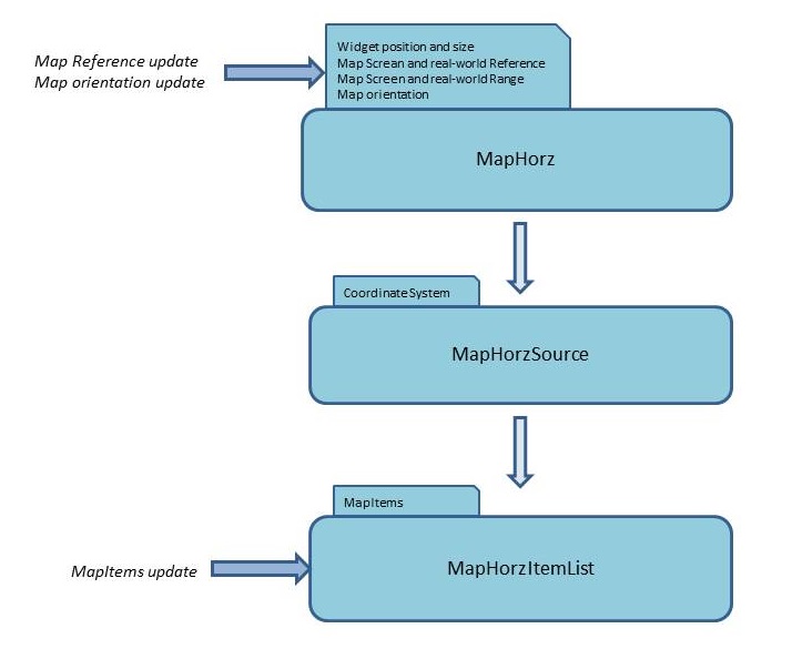
The Map architecture in the ARINC 661 standard is based on 3 types of widgets, for horizontal or vertical Maps:
An ARINC 661 Server will use a Map projection to convert MapItems (Latitude, Longitude) coordinates to their associated positions in 100th of mm.
The projection algorithm use the following characteristics:
To be able to see MapItems, you have to set the following properties in the ARINC661 server configuration properties:
The elements which are shown in Maps are called MapItems. They are not widgets whith a position defined in 100th of mm but are defined only at runtime in a real-world coordinate system (for example Latitude and Longitude).
Overview
The Map architecture in the ARINC 661 standard is based on 3 types of widgets, for horizontal or vertical Maps:
- The A661_MAPHORZ widget (or A661_MAPVERT) widget specifies the position and size of the Map on the Layer, but it also maintain the characteristics of the Map center (center of the Map in world coordinates and corresponding position on the screen) and the scale.
- The A661_MAPHORZ_SOURCE (or A661_MAPVERT_SOURCE) widget defines a projection system for all elements which will be defined under it
- The A661_MAPHORZ_ITEMLIST (or A661_MAPVERT_ITEMLIST) widget defines a projection system. It maintain lists of Map elements called MapItems. MapItems are only defined and modified at runtime
Map projection system
Main Article: ARINC661 Map projection
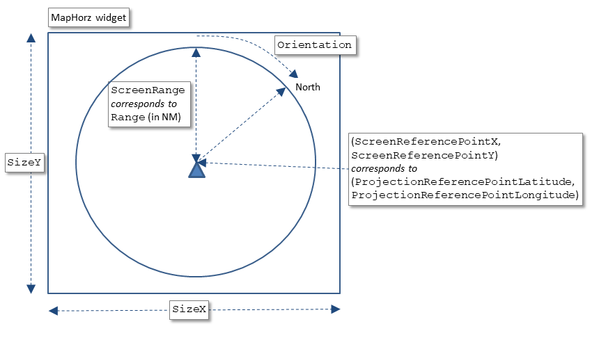
An ARINC 661 Server will use a Map projection to convert MapItems (Latitude, Longitude) coordinates to their associated positions in 100th of mm.
The projection algorithm use the following characteristics:
- The reference position of the Map (the PRP), both on the real world in (Latitude, Longitude)[1]
The (Latitude, Longitude) coordinates must be defined in degrees, but also in screen coordinates in the reference system of the MapHorz widget
- The range of the Map, both on the real world in nautical Miles, but also in screen coordinates
- The North orientation of the Map[2]
The orientation must be defined in degrees
Configuration for Maps
Main Article: ARINC661 server configuration properties
To be able to see MapItems, you have to set the following properties in the ARINC661 server configuration properties:
- The
mapUIproperty to configure the MapItems Look And Feel (see ARINC661 mapUI configuration for more information) - The
extensionsproperty to add thejfxMaps.jarMapItems library to the ARINC661 J661 extensions
- Show ARINC661 map widgets and associated MapItems
- Manage a SuperLayer with a static configuration
      # general properties
      graphics=DefGraphics.xml
      ui=LookAndFeel.xml
      pictures=DefPictures.xml
      lf=JavaFX
      supplement=8
      extensions=jfxMaps.jar
      # communication
      serverInputPort=8080
      serverOutputPort=8081
      serverInputSize=50000
      serverOutputSize=200
      maximumQueueSize=50
      # server specific properties
      server.computeLayerSize=false
      server.autoVisible=true
      # windowing
      windowManager=windows
      server.windows=sitacWindow.xml
      # maps
      mapUI=mapUIConfig.xml
Notes
See also
- UA application: The built-in UA application allows to execute an ARINC 661 Client
- Map widget tutorial: This article explains how to develop a User Application (UA) which manage a MapHorz widget
- ARINC 661 client API: Setting the Map reference: This article explains how to use the ARINC 661 Client API in the built-in UA Application module to set the Map coordinates reference
- ARINC661 map widgets: The concepts used by the ARINC 661 standard are close to those used in User interface markup languages
×
![]()
Categories: builtin-applis | uaappli