Home
Categories
Dictionary
Glossary
Download
Project Details
Changes Log
What Links Here
FAQ
License
UA ProjectionHelper
1 Overview
1.1 Accessing the class
2 Configure the ProjectionHelper
3 Get the bearing of the vector of two MapItems knowing their relative position in meters
4 Get the bearing and distance between two MapItems
4.1 Get the bearing of the vector of two MapItems
4.2 Get the distance between two MapItems
5 Conversion to/from latitude/longitude and Nautical miles
5.1 Get the East/North position of a MapItem knowing its Latitude/Longitude position
5.2 Get the Latitude/Longitude position of a MapItem knowing its East/North position
6 Conversion from a position in 100th of mm
7 Taking care of the angle units
8 See also
This article explains how the UA application
The
For example:
For example:
For example:
For example:
For example:
For example:
For example:
For example:
For example:
For example:
However, most of the methods in the helper have several versions allowing to specify which angle unit will be used. For example:
ProjectionHelper works.
Overview
Main Article: ARINC661 Map projection
The
UAAppliHelper.jar library contains a ProjectionHelper class allowing to:- get the bearing of the vector of two MapItems
- get the East/North position of a MapItems knowing its Latitude/Longitude
- get the Latitude/Longitude of a MapItems knowing its East/North position in nautical miles
- get the Latitude/Longitude of a MapItems knowing its position in 100th of mm from the dreference of the Map or from a point
Accessing the class
To be able to use theUAAppliHelper.jar library, you will need to reference it in your application configuration. For example: <applications> <application name="uaappli"> <deployment> <lib url="UAApplication.jar" /> <lib url="UAAppliHelper.jar" /> </deployment> <modules> <module name="uaappli"/> </modules> </application> </applications>
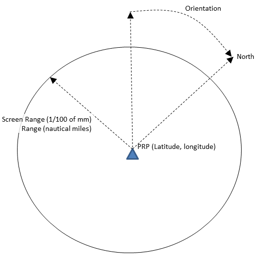
Configure the ProjectionHelper
The following methods specify the reference of the Map:- The ProjectionHelper.setPRP(double, double) set the reference point of the Map
- The ProjectionHelper.setRange(double, int) set the screen range and the range in Nautical miles
- The ProjectionHelper.setOrientation(double) set the orientation
For example:
      ProjectionHelper helper = new ProjectionHelper();
      helper.setPRP(<latitude>, <longitude>);
      helper.setRange(40, 25000); // the range is 40 nautical miles corresponding to 25000 100th of MM
Get the bearing of the vector of two MapItems knowing their relative position in meters
The ProjectionHelper.getBearing(MapPosition) return the beating between two points on the map.For example:
      MapPosition point1 = new MapPosition.Double(<latitude>, <longitude>);
      MapPosition point2 = new MapPosition.Double(<latitude>, <longitude>);
      double bearing = ProjectionHelper.getBearing(point1, point2);
Get the bearing and distance between two MapItems
Get the bearing of the vector of two MapItems
The ProjectionHelper.getBearing(MapPosition) return the bearing between two points on the map, knowiong their positions in meters relative to the center of the map.For example:
      MapPosition point1 = new MapPosition.Double(<eastNM>, <northNM>);
      MapPosition point2 = new MapPosition.Double(<eastNM>, <northNM>);
      double bearing = ProjectionHelper.getBearing(point1, point2);
The ProjectionHelper.getBearingFromLatLong(MapPosition, MapPosition) return the bearing between two points on the map, knowing their positions in (latitude, longitude).
For example:
      MapPosition point1 = new MapPosition.Double(<latitude>, <longitude>);
      MapPosition point2 = new MapPosition.Double(<latitude>, <longitude>);
      double bearing = ProjectionHelper.getBearing(point1, point2);
Get the distance between two MapItems
The ProjectionHelper.getDistanceTo(MapPosition, MapPosition) return the distance between two points on the map, knowing their positions in (latitude, longitude).For example:
      MapPosition point1 = new MapPosition.Double(<latitude>, <longitude>);
      MapPosition point2 = new MapPosition.Double(<latitude>, <longitude>);
      double bearing = ProjectionHelper.getDistanceTo(point1, point2);
Conversion to/from latitude/longitude and Nautical miles
Get the East/North position of a MapItem knowing its Latitude/Longitude position
The ProjectionHelper.getEastNorthPosition(MapPosition) return the (east, north) position of a point (in nautical miles) knowing its position in (latitude, longitude).For example:
      MapPosition point = new MapPosition.Double(<latitude>, <longitude>);
      MapPosition pointNM = ProjectionHelper.getEastNorthPosition(point);
Get the Latitude/Longitude position of a MapItem knowing its East/North position
The ProjectionHelper.getLatLongPosition(MapPosition) return the (east, north) (latitude, longitude) position of a point from the center of the Map knowing its east/north position in nautical miles.For example:
      MapPosition point = new MapPosition.Double(<eastNM>, <northNM>);
      MapPosition pointlatLong = ProjectionHelper.getLatLongPosition(point);
The ProjectionHelper.getLatLongPosition(MapPosition, MapPosition) return the (latitude, longitude) position of a point from a reference point, knowing its east/north position in nautical miles.
For example:
      MapPosition refpoint = new MapPosition.Double(<latitude>, <longitude>);
      MapPosition relativeNM = new MapPosition.Double(<eastNM>, <northNM>);
      MapPosition pointlatLong = ProjectionHelper.getLatLongPosition(refpoint, relativeNM);
Conversion from a position in 100th of mm
The ProjectionHelper.getLatLongPositionFromMM(MapPosition, MapPosition) return the (latitude, longitude) position of a point from a reference point, knowing its relative position in 100th of mm.For example:
      MapPosition refpoint = new MapPosition.Double(<latitude>, <longitude>);
      MapPosition relativeMM = new MapPosition.Double(<x_mm>, <y_mm>);
      MapPosition pointlatLong = ProjectionHelper.getLatLongPosition(refpoint, relativeMM);
The ProjectionHelper.getLatLongPositionFromMM(MapPosition, double, double) return the (east, north) (latitude, longitude) position of a point from a reference point, knowing its distance in mm and its bearing relative to the reference point.
For example:
      MapPosition refpoint = new MapPosition.Double(<latitude>, <longitude>);
      MapPosition pointlatLong = ProjectionHelper.getLatLongPosition(refpoint, <distance_mm>, <bearing_mm>);
Taking care of the angle units
By default if not specified in the methods, angles are defined in Units.DEG360.However, most of the methods in the helper have several versions allowing to specify which angle unit will be used. For example:
- ProjectionHelper.getLatLongPositionFromMM(MapPosition, double, double) will use the bearing defined in degrees
- But ProjectionHelper.getLatLongPositionFromMM(MapPosition, double, double, short) allows to specify which angle unit will be used
      double angle2 = angle + 90;
      angle2 = UnitsConverter.convert(angle2, Units.DEG, Units.DEG360);
See also
- ARINC 661 client API: This article explains how to use the ARINC 661 Client API in the built-in UA Application module
- ARINC661 Map projection: An ARINC 661 Server will use a Map projection to convert MapItems (Latitude, Longitude) coordinates to their associated positions in 100th of mm
- Map widget tutorial: This article explains how to develop a User Application (UA) which manage a MapHorz widget
- UA application: The built-in UA application allows to execute an ARINC 661 Client
×
![]()
Categories: builtin-applis | uaappli