Home
Categories
Dictionary
Glossary
Download
Project Details
Changes Log
What Links Here
FAQ
License
tacticalEnv scenario
1 Grammar
2 Content of the scenario
2.1 World configuration
2.2 FEBA
2.3 Couloirs
2.4 Zones
2.5 Targets
2.6 Bases
2.7 Threats
2.8 Aircrafts
2.8.1 Moving aircrafts
2.9 Waypoints
2.10 Flightplans
2.10.1 Flightplans list of points
2.11 Custom elements
2.12 Definition of a point
2.13 Elements description
3 Custom properties
3.1 Custom properties types
3.2 Custom properties declaration
4 Example
5 References
6 References list
7 Notes
8 See also
This article describes the content of the tactical environment scenario. Note that the scenario describes only fixed elements which will not move unless the scenario is updated.
The latitude and longitude are defined in degrees. For example:
The nature of the Zone can be:
Example:
If the
In that case the
Flightplan with only points:
The custom properties types declaration defines how to decode the XML declaration for a property. The supported values are:
The properties for an element is an array of any:
Grammar
The schema of the scenario is: confInit.xsd.Content of the scenario
The scenario contains:- A world configuration which allows to specify the reference of the scenario
- a FEBA (Front Edge of Border Area)[1]
See Front line
- Couloirs (corridors)
- Zones
- Targets
- Bases
- Threats
- Waypoints
- Flightplans[2]
See Flight plan
- Aircrafts
- Custom elements
World configuration
TheworldConfig element allows to specify the reference of the scenario. For example, it can allow to specify the center of the map to show the elements.The latitude and longitude are defined in degrees. For example:
<worldConfig latitude="44.65982" longitude="4.7377534"/>
FEBA
The grammar of thefeba element is the following:<xs:complexType name="feba"> <xs:sequence> <xs:element name="point" type="point" maxOccurs="unbounded" minOccurs="0"/> <xs:element name="property" type="property" maxOccurs="unbounded" minOccurs="0"/> </xs:sequence> </xs:complexType>Each point is constituted of a latitude and longitude in degrees. For example:
      <feba>
         <point latitude="44.91" longitude="4.9659"/>
         <point latitude="45.91" longitude="4.9659"/>
         <point latitude="46.21" longitude="5.9659"/>
      </feba>
Couloirs
The grammar of thecouloir elements is the following:<xs:complexType name="couloirs"> <xs:sequence> <xs:element name="couloir" type="couloir" maxOccurs="unbounded" minOccurs="0"/> </xs:sequence> </xs:complexType> <xs:complexType name="couloir"> <xs:sequence> <xs:element name="point" type="point" minOccurs="4" maxOccurs="4"/> <xs:element name="property" type="property" maxOccurs="unbounded" minOccurs="0"/> </xs:sequence> </xs:complexType>Each couloir has exactly 4 points which define the two sides of the couloir. See definition of a point for the definition of a point. For example:
      <couloir>
         <point latitude="44.91" longitude="4.9659"/>
         <point latitude="44.91" longitude="5.9659"/>
         <point latitude="46.21" longitude="4.9659"/>
         <point latitude="46.21" longitude="5.9659"/>
      </couloir>
Zones
The grammar of thezone elements is the following:<xs:simpleType name="zoneType"> <xs:restriction base="xs:string"> <xs:enumeration value="FRIEND"/> <xs:enumeration value="FOE"/> </xs:restriction> </xs:simpleType> <xs:complexType name="zones"> <xs:sequence> <xs:element name="zone" type="zone" maxOccurs="unbounded" minOccurs="0"/> </xs:sequence> </xs:complexType> <xs:complexType name="zone"> <xs:sequence> <xs:element name="point" type="point" maxOccurs="unbounded" minOccurs="0"/> <xs:element name="property" type="property" maxOccurs="unbounded" minOccurs="0"/> </xs:sequence> <xs:attribute name="name" type="xs:string"/> <xs:attribute name="type" type="zoneType"/> <xs:attribute name="nature" type="zoneNature"/> </xs:complexType>A Zone type can be FRIEND, FOE, or NEUTRAL, and contain a list of points. See definition of a point for the definition of a point.
The nature of the Zone can be:
- UNDEF: the default
- REFUELING: for a Refueling Zone
- SAM: for a Surface-to-air missile Zone
- TASK: for a Zone corresponding to a task
- RESPONSABILITY: for a Responsability Zone
- DELIVER_WEAPON: for a Weapon delivery Zone
- JTAC: for a Joint terminal attack controller
- NSTL: for a No Strike List
Example:
      <zone type="FRIEND" nature="REFUELING">
         <point latitude="44.91" longitude="4.9659"/>
         <point latitude="45.91" longitude="4.9659"/>
         <point latitude="46.21" longitude="5.9659"/>
      </zone>
Targets
The grammar of thetarget elements is the following:<xs:complexType name="targets"> <xs:sequence> <xs:element name="target" type="target" maxOccurs="unbounded" minOccurs="0"/> </xs:sequence> </xs:complexType> <xs:complexType name="target"> <xs:sequence> <xs:element name="point" type="point" maxOccurs="1" minOccurs="1"/> <xs:element name="property" type="property" maxOccurs="unbounded" minOccurs="0"/> </xs:sequence> <xs:attribute name="name" type="xs:string" use="required" /> <xs:attribute name="type" type="xs:string" /> </xs:complexType>The type of the Target is a string which can be used by the subscribing modules as needed. A Target has one point specifying the position of this Target. See definition of a point for the definition of a point. For example:
      <target name="ucav1" type="UCAV">
         <point latitude="44.91" longitude="4.9659"/>
      </target>
Bases
The grammar of thebase elements is the following:<xs:complexType name="bases"> <xs:sequence> <xs:element name="base" type="base" maxOccurs="unbounded" minOccurs="0"/> </xs:sequence> </xs:complexType> <xs:complexType name="base"> <xs:sequence> <xs:element name="point" type="point" maxOccurs="unbounded" minOccurs="0"/> <xs:element name="property" type="property" maxOccurs="unbounded" minOccurs="0"/> </xs:sequence> <xs:attribute name="name" type="xs:string"/> </xs:complexType>A Base has one point specifying the position of this Base. See definition of a point for the definition of a point. For example:
      <base name="base1">
         <point latitude="44.91" longitude="4.9659"/>
      </base>
Threats
The grammar of thethreat elements is the following:<xs:complexType name="threats"> <xs:sequence> <xs:element name="threat" type="threat" maxOccurs="unbounded" minOccurs="0"/> </xs:sequence> </xs:complexType> <xs:complexType name="threat"> <xs:choice maxOccurs="unbounded" minOccurs="0"> <xs:element name="elementRef" type="elementRef"/> <xs:element name="elementListRef" type="elementListRef"/> <xs:element name="point" type="point"/> <xs:element name="property" type="property"/> </xs:choice> <xs:attribute name="name" type="xs:string" use="required" /> <xs:attribute name="type" type="zoneType"/> <xs:attribute name="radius" type="xs:decimal"/> <xs:attribute name="desc" type="xs:string"/> </xs:complexType>A Threat type can be FRIEND, FOE, or NEUTRAL, and contain a list of points. See definition of a point for the definition of a point. The Threat has also a radius which is defined in meters. For example:
      <threat name="SA12" type="FOE" radius="1000">
         <point latitude="44.9139542570968" longitude="4.96594265297936"/>
      </threat>
Aircrafts
The grammar of theaircraft elements is the following:<xs:complexType name="aircrafts"> <xs:sequence> <xs:element name="aircraft" type="aircraft" maxOccurs="unbounded" minOccurs="0"/> </xs:sequence> </xs:complexType> <xs:complexType name="aircraft"> <xs:choice maxOccurs="unbounded" minOccurs="0"> <xs:element name="elementRef" type="elementRef"/> <xs:element name="elementListRef" type="elementListRef"/> <xs:element name="point" type="point"/> <xs:element name="property" type="property"/> <xs:element name="flightplanDelta" type="point"/> </xs:choice> <xs:attribute name="name" type="xs:string" use="required" /> <xs:attribute name="type" type="zoneType"/> <xs:attribute name="speedNorth" type="xs:decimal"/> <xs:attribute name="speedEast" type="xs:decimal"/> <xs:attribute name="speedVertical" type="xs:decimal"/> <xs:attribute name="flightplan" type="xs:string" /> <xs:attribute name="nextWaypoint" type="xs:string" /> <xs:attribute name="desc" type="xs:string"/> </xs:complexType>An Aircraft type can be FRIEND, FOE, or NEUTRAL, and is defined by one position and optionally a speed. For example:
      <aircraft name="rafale" type="FRIEND">
         <point latitude="44.9139542570968" longitude="4.96594265297936" altitude="1000"/>
         <property name="tasked" value="true" />
      </aircraft>
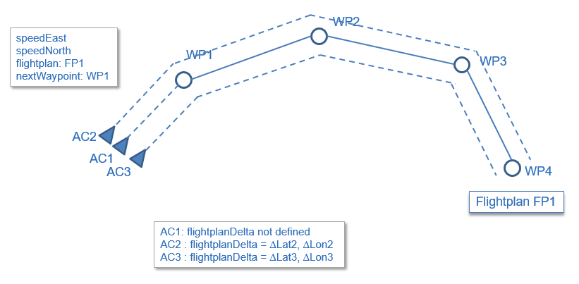
Moving aircrafts
Main Article: Activating the tactical environment
If the
flightplan property exists and points to an existing Flightplan name then the aircraft will follow the flightplan if the activate boolean property is true. The nextWaypoint property will define the next waypoint to go to from start.In that case the
flightplanDelta child (if it exists) will specify a delta position (in latitude, longitude) of the aircraft relative to the Flighplan. This allows to specify several aircrafts which will share the same Flightplan. For example:<aircraft name="AC1" type="FRIEND" flightplan="fp1" nextWaypoint="WP1" > <point latitude="44.9139542570968" longitude="4.96594265297936" altitude="1000"/> </aircraft> <aircraft name="AC2" type="FRIEND" flightplan="fp1" nextWaypoint="WP1" > <flightplanDelta latitude="-0.12" longitude="0.02"/> <point latitude="44.9139542570968" longitude="4.96594265297936" altitude="1000"/> </aircraft> <aircraft name="AC3" type="FRIEND" flightplan="fp1" nextWaypoint="WP1" > <flightplanDelta latitude="0.12" longitude="0.02"/> <point latitude="44.9139542570968" longitude="4.96594265297936" altitude="1000"/> </aircraft>
Waypoints
The grammar of thewaypoint elements is the following:<xs:complexType name="waypoints"> <xs:sequence> <xs:element name="waypoint" type="waypoint" maxOccurs="unbounded" minOccurs="0"/> </xs:sequence> </xs:complexType> <xs:complexType name="waypoint"> <xs:choice maxOccurs="unbounded" minOccurs="0"> <xs:element name="elementRef" type="elementRef"/> <xs:element name="elementListRef" type="elementListRef"/> <xs:element name="property" type="property"/> <xs:element name="point" type="point"/> </xs:choice> <xs:attribute name="name" type="xs:string" use="required" /> <xs:attribute name="type" type="xs:string" /> <xs:attribute name="desc" type="xs:string"/> </xs:complexType>A Waypoint is defined by one position and has a type (the type is a String which can be have any value and can be interpreted by the user modules). For example:
      <waypoints>
         <waypoint name="WP1">
            <point latitude="44.9139542570968" longitude="5.96594265297936"/>
         </waypoint>
         <waypoint name="WP2" type="ATT">
            <point latitude="44.9139542570968" longitude="4.96594265297936"/>
         </waypoint>
      </waypoints>
Flightplans
The grammar of theflightplan elements is the following:<xs:complexType name="flightplans"> <xs:sequence> <xs:element name="flightplan" type="flightplan" maxOccurs="unbounded" minOccurs="0"/> </xs:sequence> </xs:complexType> <xs:complexType name="flightplan"> <xs:choice maxOccurs="unbounded" minOccurs="0"> <xs:element name="elementRef" type="elementRef"/> <xs:element name="elementListRef" type="elementListRef"/> <xs:element name="waypoint" type="waypointRef"/> <xs:element name="point" type="point"/> <xs:element name="property" type="property"/> </xs:choice> <xs:attribute name="name" type="xs:string" use="required" /> <xs:attribute name="currentWaypoint" type="xs:string" /> <xs:attribute name="desc" type="xs:string"/> </xs:complexType> <xs:complexType name="waypointRef"> <xs:attribute name="name" type="xs:string" use="required" /> </xs:complexType>A Flightplan is defined by an ordered list of points, and an ordered waypoints defined by their name[3]
It means that two Flightplans can share the same Waypoints
. For example:<flightplans> <flightplan name="fp1"> <point latitude="44.9139542570968" longitude="5.96594265297936"/> <point latitude="44.9179542570968" longitude="4.96594265297936"/> <waypoint name="WP1" /> <waypoint name="WP2" /> </flightplan> </flightplans> <waypoints> <waypoint name="WP1"> <point latitude="44.9139542570968" longitude="5.96594265297936"/> </waypoint> <waypoint name="WP2" type="ATT"> <point latitude="44.9179542570968" longitude="4.96594265297936"/> </waypoint> </waypoints>
Flightplans list of points
The flightplan can have only points, onyl waypoints, or both. For example, all these definitions are valid:Flightplan with only points:
<flightplans> <flightplan name="fp1"> <point latitude="44.9139542570968" longitude="5.96594265297936"/> <point latitude="44.9179542570968" longitude="4.96594265297936"/> </flightplan> </flightplans>Flightplan with only waypoints:
<flightplans> <flightplan name="fp1"> <waypoint name="WP1" /> <waypoint name="WP2" /> </flightplan> </flightplans> <waypoints> <waypoint name="WP1"> <point latitude="44.9139542570968" longitude="5.96594265297936"/> </waypoint> <waypoint name="WP2" type="ATT"> <point latitude="44.9179542570968" longitude="4.96594265297936"/> </waypoint> </waypoints>Flightplan with points and waypoints:
      <flightplans>
         <flightplan name="fp1">
            <point latitude="44.9139542570968" longitude="5.96594265297936"/>
            <point latitude="44.9179542570968" longitude="4.96594265297936"/>
            <waypoint name="WP1" />
            <waypoint name="WP2" />
         </flightplan>
      </flightplans>
      <waypoints>
         <waypoint name="WP1">
            <point latitude="44.9139542570968" longitude="5.96594265297936"/>
         </waypoint>
         <waypoint name="WP2" type="ATT">
            <point latitude="44.9179542570968" longitude="4.96594265297936"/>
         </waypoint>
      </waypoints>
Custom elements
It is possible to specify elements of any kinds under theelements node. For example, here we define two mission and two frequency elements:<elements> <element name="mission1" type="mission"> <property name="tasked" value="true"/> </element> <element name="mission2" type="mission"> <property name="tasked" value="true"/> </element> <element name="diamond12_UHF" type="frequency"> <property name="frequency" value="239.650" /> <property name="canal" value="12" /> </element> <element name="diamond12_VHF" type="frequency"> <property name="frequency" value="150.150" /> <property name="canal" value="12" /> </element> </elements>
Definition of a point
A point is constituted of a latitude and longitude in degrees. For example:<zone type="FRIEND"> <point latitude="44.91" longitude="4.9659"/> <point latitude="45.91" longitude="4.9659"/> <point latitude="46.21" longitude="5.9659"/> </zone>It is possible to define each point coordinates with two different patterns:
- Directly in degrees. For example
44.91specifies a value of 44.91 degrees - In degrees / minutes / 1000th of minutes. For example
44'30'500specifies a value of 44 degrees, 30 minutes, and 500 1/1000th of minutes
Elements description
All the elements can have an optional description. This description is only use to document the scenario and will not be parsed. For example:<target name="ucav1" type="UCAV" desc="the mission target"> <point latitude="44.91" longitude="4.9659"/> </target>
Custom properties
It is possible to define custom properties which can be used for any element. The declaration of these custom properties has two parts:- The declaration of the properties types at the beginning of the scenario file
- The declaration of the properties for an element
Custom properties types
Main Article: tacticalEnv structure file
The custom properties types declaration defines how to decode the XML declaration for a property. The supported values are:
- string
- int
- float
- boolean
      <propertyTypes>
         <propertyType name="video" type="int" />
      </propertyTypes>
We declare that the
video property is an int.
Custom properties declaration
Main Article: tacticalEnv structure file
The properties for an element is an array of any:
      <arrayType name="propertyArray" type="property" />
      <structType name="property">
         <field name="name" type="string" />
         <field name="value" type="any" />
      </structType>
The type of a property will be the type defined for the property name in the custom properties types declaration. If this property has no defined type, it will be a string.
Example
      <configuration>
         <propertyTypes>
            <propertyType name="video" type="int" />
         </propertyTypes>
         <targets>
            <target name="SA_12_Bill_Board_47" type="bill board">
               <point latitude="44.913" longitude="4.965"/>
               <property name="video" value="47" />
            </target>
         </targets>
      </configuration>
References
All elements have an optional list ofelementRef references to other elements. For example:<zone name="myZone" type="NEUTRAL" nature="JTAC"> <point latitude="44.280514" longitude="5.33035"/> <point latitude="44.38048" longitude="5.33035"/> <point latitude="44.38048" longitude="5.430317"/> <point latitude="44.280514" longitude="5.430317"/> <elementRef name="frequency" eltType="frequency" eltName="diamond14"/> </zone> <elements> <element name="diamond14" type="frequency"> <property name="frequency" value="251.175" /> <property name="canal" value="12" /> </element> </elements>Note that an
elementRef reference only refer to one element. If you want to specify one reference to a list of elements of the same type, you should rather use an elementListRef (see references list).
References list
AnelementListRef element specifies a reference to a list of elemetns of the same type. For example here the element1 custom element uses a list of Zones:<configuration> <zones> <zone name="zone1" nature="TASK"> <point latitude="0" longitude="0"/> <point latitude="2" longitude="2"/> <point latitude="3" longitude="3"/> </zone> <zone name="zone2" nature="TASK"> <point latitude="0" longitude="0"/> <point latitude="2" longitude="2"/> <point latitude="3" longitude="3"/> </zone> </zones> <elements> <element name="element1" type="TheElement"> <elementListRef name="theRef" type="Zone"> <ref eltName="zone1" /> <ref eltName="zone2" /> </elementListRef> </element> </elements> </configuration>
Notes
- ^ See Front line
- ^ See Flight plan
- ^ It means that two Flightplans can share the same Waypoints
See also
- tacticalEnv Application: The built-in tacticalEnv Application allows to manage a tactical environment
×
![]()
Categories: builtin-applis