Home
Categories
Dictionary
Glossary
Download
Project Details
Changes Log
What Links Here
FAQ
License
Map ontology requestEngine module
1 Overview
2 Specify the module interfaces
3 Code the request UI
4 Code the request generation
4.1 Creating the query for the alerts list
4.1.1 Adding the variables in the query
4.1.2 Implementing the query triple patterns
4.1.3 Finalizing and invoking the query
4.2 Creating the query for the waypoint distance
4.2.1 Adding the variables in the query
4.2.2 Implementing the query triple patterns
4.2.3 Implementing the geometry query
4.2.4 Finalizing and invoking the query
4.3 Creating the query for the closest ATT waypoint
4.3.1 Adding the variables in the query
4.3.2 Implementing the query triple patterns
4.3.3 Implementing the geometry query
4.3.4 Limit to the closest result
4.3.5 Finalizing and invoking the query
5 Code the query result notification
5.1 Handle the alert list query
5.2 Handle the waypoint distance query
5.3 Handle the closest ATT waypoint query
6 Notes
7 See also
This article presents the requestEngine module used in the second map ontology tutorial.
Several queries will be handled:
Overview
The requestEngine module is responsible to:- Generate SPARQL requests using the Jena SPARQL request creation framework
- Process object responses
Specify the module interfaces
The requestEngine module has the following module configuration:<application name="requestEngine"> <deployment> <lib url="RequestEngine.jar" /> </deployment> <modules> <module name="requestEngine"> <implementation path="org.da.request.RequestEngine" > <initEntryPoint method="init" /> <defaultReceiveEntryPoint method="subscribe" /> </implementation> <interfaces> <requestSend service="owlObjectRequest" uri="http://dassault-aviation.com/jena" /> </interfaces> </module> </modules> </application>It will be notified from the
http://dassault-aviation.com/jena:owlObjectRequest service.
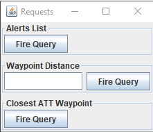
Code the request UI
We will create a window to ask the requests:
Several queries will be handled:
- Alerts List: the query to return the list of alerts and their type
- Waypoint Distance: the query to return the distance of a Waypoint
- Closest ATT Waypoint: the query to return the name and the distance of the closest ATT Waypoint
      public interface RequestGUIListener {
         public void queryAlertsList();

         public void queryWaypointDistance(String waypointID);

         public void queryClosestATTWaypoint();
      }
Code the request generation
The module implements theRequestGUIListener interface:- The
queryAlertsList()method generates the query to return the list of alerts and their type - The
queryWaypointDistance(String waypointID)method generates the query to return the distance of a Waypoint - The
queryClosestATTWaypoint()method generates the query to return the name and the distance of the closest ATT Waypoint
Creating the query for the alerts list
The hand-written-query would be[1]
See alerts requests in the first tutorial
:SELECT ?number ?type WHERE { ?alarm rdf:type inav:Alarm . ?alarm inav:AlarmNumber ?number . ?alarm inav:hasAlarmType ?type . }First we will create a request with the ontology schema:
SparqlRequest request = new SparqlRequest("inav");
Adding the variables in the query
As you can see there are two variables in theSELECT construct. We must add these variables in the query:request.addSelect("number"); request.addSelect("type");We also have an additional
alarm variable which is used but not included in the SELECT:request.addAdditionalVariable("alarm");
Implementing the query triple patterns
Thealarm variable is of the Alarm type: request.addType("alarm", "Alarm");The
alarm variable has the number variable as the AlarmNumber property:request.addPropertyRef("alarm", "AlarmNumber", "number");The
alarm variable has the type variable as the hasAlarmType property:request.addPropertyRef("alarm", "hasAlarmType", "type");
Finalizing and invoking the query
The full code is:public void queryAlertsList() { SparqlRequest request = new SparqlRequest("inav"); request.addSelect("number"); request.addSelect("type"); request.addAdditionalVariable("alarm"); request.addType("alarm", "Alarm"); request.addPropertyRef("alarm", "AlarmNumber", "number"); request.addPropertyRef("alarm", "hasAlarmType", "type"); objectRequestService.setDataStringValue("reqSchema", "inav"); objectRequestService.setDataStringValue("query", request.toString()); objectRequestService.invoke(); }
Creating the query for the waypoint distance
The hand-written-query would be (here for theWPT6 waypoint):SELECT ?label ?distance WHERE { ?wpt rdf:type inav:Waypoint . ?wpt inav:Label ?label . ?wpt inav:Label "WPT6" . ?ac rdf:type inav:Aircraft . ?ac inav:Label "falcon" . ?wpt inav:hasExactGeometry ?auto_2 . ?auto_2 inav:asWKT ?auto_3 . ?ac inav:hasExactGeometry ?auto_4 . ?auto_4 inav:asWKT ?auto_5 . BIND (geof:distance(?auto_3, ?auto_5, <http://www.opengis.net/def/uom/OGC/1.0/nauticalMile>) as ?distance) }First we will create a request with the ontology schema:
SparqlRequest request = new SparqlRequest("inav");
Adding the variables in the query
There are two variables again in theSELECT construct. We must add these variables in the query:request.addSelect("label"); request.addSelect("distance");We also have two additional
wpt and ac variables which represent respectively the Waypoint and the Aircraft:request.addAdditionalVariable("wpt"); request.addAdditionalVariable("ac");
Implementing the query triple patterns
Thewpt variable represents a Waypoint:request.addType("wpt", "Waypoint");We use the Waypoint ID passed as an argument to the method to specify its label. As you can see, we use a
PropertyRef for the wpt variable to link to the label variable, but we also use a PropertyValue for the same variable to link to our Waypoint ID argument.request.addPropertyRef("wpt", "Label", "label"); request.addPropertyValue("wpt", "Label", waypointID);We must do the same thing for the Aircraft:
      request.addType("ac", "Aircraft");
      request.addPropertyValue("ac", "Label", "falcon");
Implementing the geometry query
One unique construct will allow us to generate the part of the query which will compute the distance between the Waypoint and the Aircraft:request.addDistance("wpt", "ac", "distance", ISparqlRequest.DISTANCE_NM, true);
Finalizing and invoking the query
The full code is:public void queryWaypointDistance(String waypointID) { SparqlRequest request = new SparqlRequest("inav"); request.addSelect("label"); request.addSelect("distance"); request.addAdditionalVariable("wpt"); request.addAdditionalVariable("ac"); request.addType("wpt", "Waypoint"); request.addPropertyRef("wpt", "Label", "label"); request.addPropertyValue("wpt", "Label", waypointID); request.addType("ac", "Aircraft"); request.addPropertyValue("ac", "Label", "falcon"); request.addDistance("wpt", "ac", "distance", ISparqlRequest.DISTANCE_NM, true); objectRequestService.setDataStringValue("reqSchema", "inav"); objectRequestService.setDataStringValue("query", request.toString()); objectRequestService.invoke(); }
Creating the query for the closest ATT waypoint
The hand-written-query would be:SELECT ?label ?distance WHERE { ?wpt rdf:type inav:Waypoint . ?wpt inav:Label ?label . ?wpt inav:hasWaypointType <http://localhost/INAV#ATT> . ?ac rdf:type inav:Aircraft . ?ac inav:Label "falcon" . ?wpt inav:hasExactGeometry ?auto_2 . ?auto_2 inav:asWKT ?auto_3 . ?ac inav:hasExactGeometry ?auto_4 . ?auto_4 inav:asWKT ?auto_5 . BIND (geof:distance(?auto_3, ?auto_5, <http://www.opengis.net/def/uom/OGC/1.0/nauticalMile>) as ?distance) } ORDER BY ASC( ?distance ) LIMIT 1? ac rdf:type inav:Aircraft . ?ac iFirst we will create a request with the ontology schema:
SparqlRequest request = new SparqlRequest("inav");
Adding the variables in the query
There are two variables again in theSELECT construct. We must add these variables in the query:request.addSelect("label"); request.addSelect("distance");We also have two additional
wpt and ac variables which represent respectively the Waypoint and the Aircraft:request.addAdditionalVariable("wpt"); request.addAdditionalVariable("ac");
Implementing the query triple patterns
Thewpt variable represents a Waypoint:request.addType("wpt", "Waypoint");We only look for ATT Waypoint, so we will look for Waypoints which have an
ATT type:request.addPropertyIndividualRef("wpt", "hasWaypointType", "ATT");We use a
PropertyRef for the wpt variable to link to the label variable:request.addPropertyRef("wpt", "Label", "label");We must do the same thing for the Aircraft:
      request.addType("ac", "Aircraft");
      request.addPropertyValue("ac", "Label", "falcon");
Implementing the geometry query
One unique construct will allow us to generate the part of the query which will compute the distance between the Waypoint and the Aircraft:request.addDistance("wpt", "ac", "distance", ISparqlRequest.DISTANCE_NM, true);
Limit to the closest result
We will sort the results by ascending distance, and get only the first one, to get the closest:request.setLimit(1); request.setOrderBy("distance", true);
Finalizing and invoking the query
The full code is:public void queryClosestATTWaypoint() { SparqlRequest request = new SparqlRequest("inav"); request.addSelect("label"); request.addSelect("distance"); request.addAdditionalVariable("wpt"); request.addAdditionalVariable("ac"); request.addType("wpt", "Waypoint"); request.addPropertyIndividualRef("wpt", "hasWaypointType", "ATT"); request.addPropertyRef("wpt", "Label", "label"); request.addType("ac", "Aircraft"); request.addPropertyValue("ac", "Label", "falcon"); request.addDistance("wpt", "ac", "distance", ISparqlRequest.DISTANCE_NM, true); request.setLimit(1); request.setOrderBy("distance", true); objectRequestService.setDataStringValue("reqSchema", "inav"); objectRequestService.setDataStringValue("query", request.toString()); objectRequestService.invoke(); }
Code the query result notification
Now we will write the code dealing with the object query result:public void subscribe(ServiceInstance service) { NamespaceKey JENA_OBJECT_REQUEST = NamespaceKey.createKey("http://dassault-aviation.com/jena", "owlObjectRequest"); NamespaceKey key = service.getKey(); if (key.equals(JENA_OBJECT_REQUEST)) { QueryResults results = (QueryResults) service.getData("response").getValue(); handleObjectResponse(results); } }We will handle the notification depending on the query we sent in the
handleObjectResponse(QueryResults results) method.
Handle the alert list query
First we will print the number of alerts:System.out.println("Number of Alerts: " + results.countResults());Each result correspond to an Alert with two values for the
number and type variables:QueryResults results = (QueryResults) service.getData("response").getValue(); Iterator<QueryResults.Result> it = results.getOrderedResultsList().iterator(); while (it.hasNext()) { QueryResults.Result result = it.next(); int number = result.getValue("number").getValueAsInt(); String type = result.getValue("type").getValueAsString(); System.out.println("Alarm " + number + ": " + type); }
Handle the waypoint distance query
Here we have only one result, for which we will print the values for thelabel and distance variables:QueryResults.Result result = results.getOrderedResultsList().iterator().next(); String label = result.getValue("label").getValueAsString(); double distance = result.getValue("distance").getValueAsDouble(); System.out.println("Distance of Waypoint " + label + " at " + distance + " NM");
Handle the closest ATT waypoint query
Here we have only one result, for which we will print the values for thelabel and distance variables:QueryResults.Result result = results.getOrderedResultsList().iterator().next(); String label = result.getValue("label").getValueAsString(); double distance = result.getValue("distance").getValueAsDouble(); System.out.println("Closest ATT Waypoint is " + label + " at " + distance + " NM");
Notes
- ^ See alerts requests in the first tutorial
See also
- Second map ontology tutorial: This synthetic map tutorial allows to construct requests in Java, and the results are returned as objects
- Jena SPARQL request creation: This article presents the utility class which allows to create SPARQL requests
- Jena object responses: This article presents how the SPARQL requests work in Jena
×
![]()
Categories: tutorials